This is about RAIL GRADE SEPARATION, not about multi-hundred-million-per-crossing massive extensive road excavation and utility relocation consultant wankfests consuming Other People's Money
Attempts have been made to make the diagrams (embedded SVG format image files) below zoomable and scrollable using "the usual" mouse/touch gestures, but this is all been a web browser nightmare, and there's only so much I could manage.
Mousing over individual drawn elements (curves, crossing, etc) of the diagrams will reveal ridiculous amouts of detail about each. Clicking on an element should copy that information to the clipboard.
The base Caltrain elevation data were painfully hand-transcribed from hundreds of pages of PDF files not intended for this purpose. Errors are inevitable.
Contribution of machine-readable Caltrain alignment data would of course have been welcomed, and of course shouold be readily and publically available, but that is not the world in which we live.
Corrections are very welcome.
Suggestions for improvements are welcome.
Common non-PTG non-TJPA non-PCJPB non-CHSRA non-batshit-insane non-$1+bn "Pennsylvania Avenue Extension" elements to any rational extension to the Transbay Terminal:
16th Street in SF remains (close to) at-grade, rails go under. Tracks trenched between most existing Highway 280 viaduct bent foundations.
Lateral relocation of several bent columns is required, but this is a basic basic Caltrans competency, one demonstrated repeatedly in freeway seismic retrofit and freeway widening (always widening, always widening, Caltrans gotta Caltrans) projects.
For a coulda-shoulda (but didn't, because we only every employ the very worse quality people at "pubic" agencies in the USA) non-braindead non-PTG DTX via Second Street alignment:
Three tracks, three 420m platform faces, any-train any-platform.
The station is NOT excavated two levels deep below Townsend Street, below an unnecessary access-inhibiting mezzanine level, and not dug at immense expenditure of Other People's Money cost solely to further some trivial penny-ante low-rise quarter-of-a-city-block real estate pipe dream scam veto coming from the corrupt puppets of the San Francisco "Planning" Department.)
In comparison, braindead PTG "consensus" alignment features:
In short, America's Finest Transportation Planning Professionals, doing what they do best, which is self-serving self-enriching outright unambiguous fraud.
16th Street in SF remains (close to) at-grade, rails go under. Tracks trenched between most existing Highway 280 viaduct bent foundations.
Lateral relocation of several bent columns is required, but this is a basic basic Caltrans competency, one demonstrated repeatedly in freeway seismic retrofit and freeway widening (always widening, always widening, Caltrans gotta Caltrans) projects.
See 202111-Seventh-and-Townsend-Station.pdf drawing for further details.
See Caltrain-HSR blog " Focus On: Mission Bay Grade Separations" (January 2014! How time flies! How impossibly badly "public" agencies perform!) for some addditional under-280 information
Seventh and Townsend Mission Bay station trenched (no insane mezzanine, no multi-hundred-million fire safety impact) largely within the Caltrain yard right of way.
Taking of one low-rise building at the corner of Seventh and Townsend, minor easements adjacent.
Bare passage under Central Subway bore at Fourth and Howard, not at all dissimilar to the bare passage of the Central Subway itself under the BART and Muni station under Market Street.
It Can Be Done. It has Been Done, just two blocks away, just a few years ago.
Clear passage (30+ feet) under Moscone Center halls under Howard Street.
Undoubtedly there are piles, undoubtedly this is a mere civil engineering problem, one with manageable and straightforward solutions.
Universal (any track to any track with absolute minimum route comflicts) compact (quicker train clearance times mean higher throughput) TTT approach throat/interlocking, using standard geometry UIC 1:9 turnouts based on a 300m diverging radius curved (per absolutely standard UIC practice) down to 200m diverging and 333m non-diverging radii.
See Caltrain-HSR blog "Transbay Update " (December 2012! Où sont les neiges d'antan?) for basic explanation of route conflicts and train throughput.
Miraculously, and not by anybody's design or forethought — the exact opposite, in fact — the universal interlocking throat can be tied into the disastrously misconfgured PTG approach curves (heading towards Second Street, mistakenly) to the TTT platforms with only minor impacts (lateral shifts) to at most three structural columns!
Amazingly lucky.
See 202110-Howard.pdf drawing for further details.
Rail over road at Linden Avenue.
Scott Street closure unavoidable, given proximity of evil Highway 380 road overpass.
The vertical curve of the southern tie-in from the Linden overcrossing precisely matches the existing vertical curve under 380 rising towards the existing San Bruno Station.
Rail over road at Center Street.
This blindingly obvious grade separation was deliberately excluded — in order to maximize public costs and private profits — by the criminals responsible for the BART to Millbrae extension in the 1990s.
All reponsible remain out of jail, and several (Steve Heminger, Takis Salpeas, more) remain in positions of great power where they continue to inflict billions of dollars of further damage on "public" transportation agencies and to the global environment.
Also indicated is an option to raise rail as much as possible (~ +10ft) to reduce the depth of the deadly (literally deadly) Hillcrest Boulevard.
Hillcrest was required to be excavated and dive under the Caltrain tracks, while passing over immediately-adjacent buried BART tracks, buried solely to maximize BART contractor profits.
Those responsible remain out of jail, inexplicably.
We know who they are. There are no consequences.
We are doomed.
Richard Mlynarik 22 June, 2021 15:00
Linden Avenue (incomprehensibly and inexcusably removed from Caltrain's San Bruno project scope, because doing things really really badly, twice or more, and at mind-melting expense, is Caltrain's entire raison d'être).
The Linden vertical profile matches up nicely with the 50mph (note 50mph, not 60 here of Caltrain's own recent project!) 16620m radius AREMA freight curve of the toady's line climbing under the Highway 280 overpass to 1.25% (note 1.25%, not "limited" to 1% even on Caltrain's own recent project) up to the disastrously-wrongly San Bruno station.
- It is simply infeasible to grade separate Scott Street due to the adjacent Highway 380 overpass and so it must close. Sorry.
Center Street in Millbrae, for whose presence and pain we must every day give thanks to our BART extension lunatics and abetters, including MTC and now SFMTA's Very Special Guy, Steve "$5 billion Bay Bridge budget blowout" Heminger, the Highway Contractor's Eternal Friend. Believe it or not BART goes under Center in an insane cost-exploding cut-and-covered tunnel, while Caltrain's grade was raised along with the road to make this happen. Anyway, Caltrain needs to go even higher to clear now. Thanks, Steve! Thanks, Quentin ! Thanks, Takis! Thanks PBQD/Bechtel! Thanks Tutor-Saliba!
As mentioned earlier, I've just gone with big-ass 16383m radius vertical curves and 1% grades here and elsewhere: tighter and steeper would be better and cheaper.
And note that these and the majority of all other sketched separations would be ridiculously infeasible if Caltrain's newly ass-extracted "no vertical curves on a bridge" thing were a thing anybody should believe in any way. These little up-and-over-and-down isolated single-road separations in particular would blow out crazily otherwise. Purest rent-seeking graft, grift and lunacy.
Clem 10 May, 2021 19:05
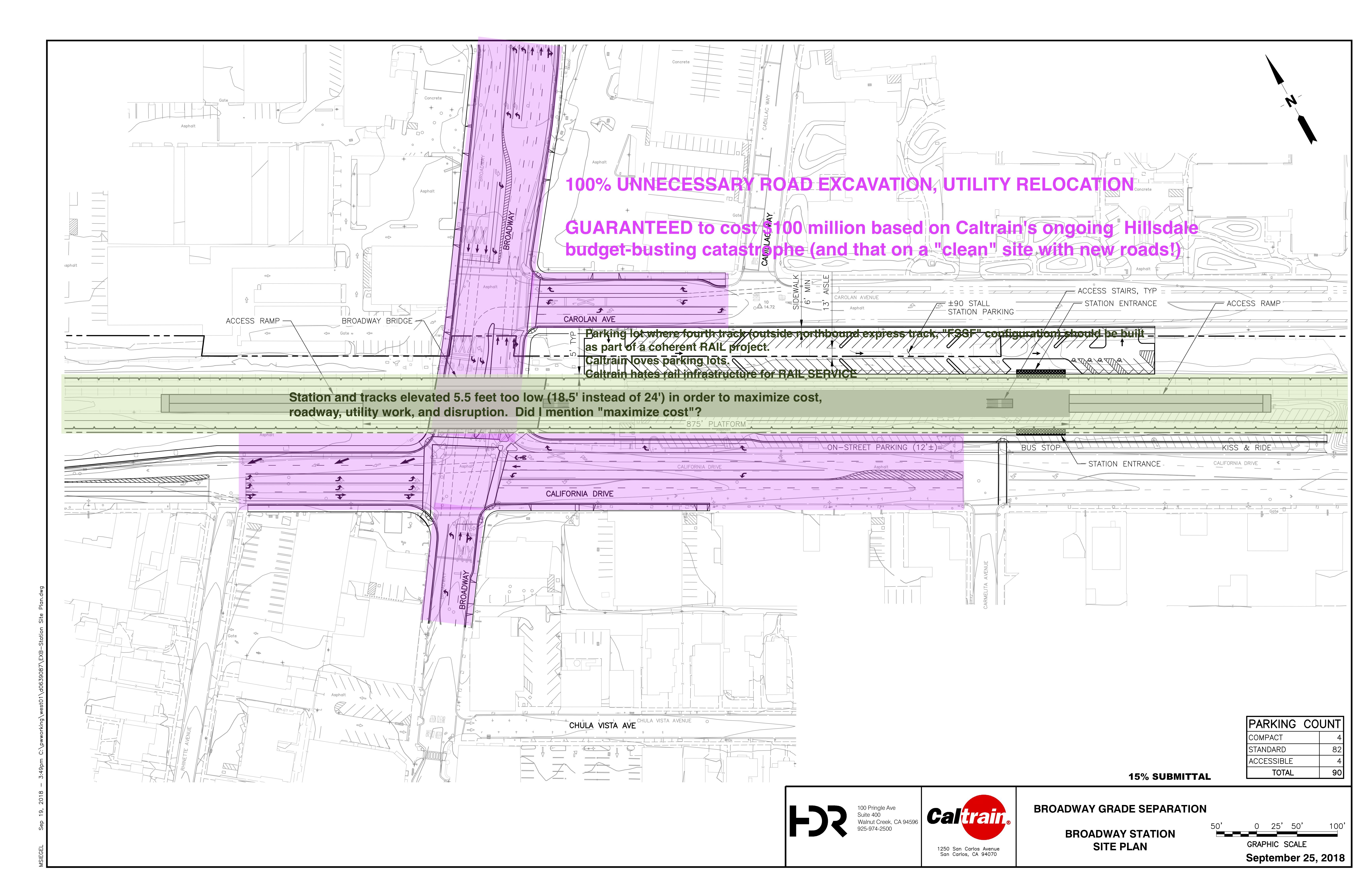
It was pointed out to me that one of the key reasons for the astronomical cost of the Broadway project is that it includes 3.5 acres of roads and sidewalks that will be lowered, resulting in 3.5 acres of utility relocation. Raising the tracks another few feet would take care of this problem, although it is more likely that scarce grade separation monies will instead be used to assist the City of Burlingame's public works budget with 3.5 acres of new pavement and new utilities.
It's a perfectly logically crafted story: CP Trousdale to the north "constrains" the length of the grade separation structure, which combined with 60 mph freight speed and 1% grade design rules "prevent" the structure from being sufficiently elevated over Broadway, which in turn "requires" 3.5 acres of utilities to be relocated and 3.5 acres of roads and sidewalks to be rebuilt.
Richard Mlynarik 19 May, 2021 15:01
It's a perfectly logically crafted story: CP Trousdale to the north "constrains" the length of the grade separation structure, which combined with 60 mph freight speed and 1% grade design rules "prevent" the structure from being sufficiently elevated over Broadway, which in turn "requires" ...It's also a story that is laughably, insultingly fraudulent. No question about it: Caltrain's staff and Caltrain's perma-temp consultant mafia are simply outright lying. Their sole priorities are cost maximization and self-enrichment.
This is simplest second grader arithmetic.
Consider:
- Northern match point of their service-destroying, budget-exploding Broadway scam project into existing tracks is at +0.1534% grade and 860+ feet (feet! in 2021!) clear of the Sacred Crossover of CP Trousdale.
- Southern match at grade +0.6031% (again rising to the south) 350+ feet north of the inexplicably-out-of-scope Oak Grove Avenue grade crossing.
- Because we're masochists we're going to play by the cost-maximizing "design" "standards" Caltrain's consultants are "forced" into. In fact, we're going to use exactly the existing grades of the Caltrain scam, and use the same 60mph AREMA freight vertical curves (even though the freight speed everywhere on Caltrain is ≤50mph and even through recent Caltrain projects in San Bruno and San Mateo have sub-45mph vertical curves), and use the same scam 1% grade "limit" (though Caltrain's recent San Bruno project exceeds this), and use the same over-the-top stream-train-compatible Caltrain bridge depth. We're also going with Caltrain's insane "standard" of no vertical curves within 100 feet of a platform (this truly makes zero sense.)
OK! Now ... a solution!
Move the start of the northern grade 500 feet north. (NB Everything's roughly similar varying this from 420 to 600 feet.)
Note this is 360+ safe feet from The Holiest of Holy Crossovers of CP Trousdale, all abase yourselves before CP Trousdale, amen.
This 500 feet of extra run buys 4.23 feet of elevation (recall +1.0000% - +0.1534%)
Move the end of the northern grade 127 feet south.
Note this is still 150+ feet from the platform as "designed" by Caltrain.
This extra run buys another 1.27 feet of elevation.
Oh look! We're now 5.5 feet higher than Caltrain's "design". FREE AND CLEAR!
ONE GUESS how deeply they "need" to excavate Broadway, California Drive and Carolan Avenue for their $330+ million road-reconstruction and utility-relocation pork-fest!
Move the platform north end 50 feet north.
Raise platform to 760mm ATOR for level boarding, which would be the standard if Caltrain weren't run by chimps.
Extend platform by 110 feet (ie 300m long platform, ie 2x150m = 2x6-"car" coupled trains, ie what should be the shortest platform on the line, not the 700 feet or 875 feet or whatever the chimps pull out of their rear ends this month.)
Start downgrade vertical curve 88 feet further north.
Note this is 100 pointless feet clear of 300m platform.
This buys 0.88 feet of the 5.5 feet we need to lose.
End downward grade 288 feet further south.
Note this is about 60 feet from Oak Grove, but there's no geometrical or rail dynamic or rail maintenance reason to object to this.
This buys the remaining 4.62 vertical feet needed (at -1.0000% - +0.6031%)
DONE. We CAN get over Broadway without "fatal impact" to holy untouchable CP Trousdale.
So yeah, looks like Caltrain staff and Caltrain's perma-temp consultant mafia are lying about "needing" to excavate.
Who'd have guessed?
I mean, with $330 million and rocketing upwards at stake, who'd POSSIBLY IMAGE anybody would lie through their teeth in order to maximize public-private wealth transfer?
I mean, it's not like this has ever happened before, right?
The grift is the point. Grift is the only point.
Richard Mlynarik 19 May, 2021 15:14
one of the key reasons for the astronomical cost of the Broadway project is that it includes 3.5 acres of roads and sidewalks that will be lowered, resulting in 3.5 acres of utility relocation. Raising the tracks another few feet would take care of this problem, although it is more likely that scarce grade separation monies will instead be used to assist the City of Burlingame's public works budget with 3.5 acres of new pavement and new utilities.The First Law of Holes is "Stop digging!"
Richard Mlynarik 22 June, 2021 15:32A bunch of stuff here, because all potential quasi-independent sub-projects for different subsets of roads interact, mostly quite strongly.
- Broadway Burlingame (one street, alone) is shown per Caltrain's bat-shit-insane, actively harmful out-to-bid-before-you-known-it $300+ million for a single road grade separation scam.
- Broadway Burlingame (one street, alone) also with the minimal and perfectly feasible change of fully elevating the tracks and avoiding all road excavation, even while [adhering] to batshit Caltrain design "standards". (Also show with 50mph freight curves, just to show how that tightens things up. 45mph freight and 1.25% 1.5% and 2% grades even better.
Oak Grove Avenue Burlingame is blindingly obviously part of any "Broadway" project, but of course Caltrain prefers to do everything at least twice, and terribly every time.
Once you're up and over Broadway it's just a small extra bump to keep going and deliver two grade separations for the same amount of staging cost and time and service interruption.
Caltrain's actual Broadway project is not just oblivious of Oak Grove, but actively incompatible with it. As it is with quadruplication of any sort. Of course. Of course.
I've included both 50mph and 45mph freight profiles, just to show how the more elephantine curves of the former lead to a violation of a 1% grade "design requirement" (to a scandalous 1.060%) if the tracks are to descend and match grade before North Lane and the existing Burlingame station. Obviously 45mph and 1.25% or 1.5% or 2.0% would be even better.
Downtown Burlingame (North Lane, Howard, Bayswater, Peninsula, Villa Terrace, Bellevue Avenue
Should all be done of a piece with Broadway plus Oak Grove, and as you can see the bump-up-and-over-then-down-again profile of the Oak Grove bridge done separately from downtown is slightly incompatible (more elevated than, going up an extra 6 plus feet and going up earlier in order to make it possible to go down quickly enough) a more integrated Burlingame-wide program.
Insane penny-ante local government politics aside, the logistics and constructibility (plenty of ROW for shooflies and staging) of going elegantly over downtown Burlingame are pretty simple. Or would be in a first world industrialised functional democracy with rudimentary engineering competence.
Taken as a separate project from further grade separations through San Mateo, there are trade-offs in getting down to match grade at the southern end, and how that touch-down point impacts onward grade separation.
- To minimally touch San Mateo, matching grade around Santa Inez Avenue, the descending grade cannot clear Bellevue Avenue and so Bellevue would be closed to motor vehicle traffic, with a very easy direct pedestrian underpass. Tighter curves and steeper grades don't make much of a difference here.
To clear Bellevue moves the return-to-existing-grade match point south to near Tilton Avenue, and involves another total do-over (a desirable do-over, achieving full 16 foot road traffic vertical clearance of these sub-standard crossings) of the Poplar, Santa Inez and Monte Diablo road under crossings. And this impacts any further southward grade separation of downtown San Mateo.
And speaking of grades in San Mateo, not that Caltrain's just-completed bridge raising project here comes with 43mph freight curves (three of them under 12700m radius!) So much for 60mph freight "requirements", huh. Crazy stuff. Crazy crazy stuff.
Downtown San Mateo: It's obvious what to do here, though constructibility is bear given restricted ROW north of Ninth Avenue. A fairly extended total interruption of rail service is unavoidable. But so worth it.
In principle though, not a hard engineering project, and one that would have a really nice outcome for Caltrain and for San Mateo.
But yeah, dream on.
Matching grade at the southern end is simple. The northern, Burlingame end less so, and the interactions with downtown Burlingame separation aren't horribly complicated but they aren't trivial, particularly around project phasing.
Richard Mlynarik 22 June, 2021 21:52So this has got to be pretty simple, right? Just four existing grade crossings to clear (Encinal, Glenwood, Oak Grove, Ravenswood), and the existing grade kind-of flattish through northern half of Menlo.
But no! A rising grade from Atherton into Menlo Park means we have to climb steeper to gain the requisite road clearance, and, well, anything that touches Atherton turns toxic.
As nearly everywhere, the correct solution is rails raised 6.7m above existing grade (4.8m 15.75ft of road clearance plus ugly obese American 1.9m depth of rail bridge civil and track) with 300m long station platform nicely placed over cross-streets for good connecting transit and good pedestrian accessibility. That's easy! (Oak Grove—Ravenswood road spacing is even close to 300m, just for us!)
But getting 6.7m of elevation is made harder at the northern, Atherton end by a +0.27% rising grade, and ... by the objective fact that the Town of Atherton is ruled by sociopaths.
My self-imposed constraint is to not do any construction in Atherton (as much as elevated tracks would be quieter and less dangerous and less CLANG CLANG CLANG CLANG HONK HONK HONK) meaning leave Watkins Avenue in Atherton – little more than 500m north of Encinal Avenue in Menlo Park – as a CLANG CLANG CLANG HONK HONK SMASH SMASH grade crossing while Encinal is grade separated.
But +6.7m rise in 500m run, all handicapped by 0.27% against, is ... not favourable.
Even with a +2.00% grade (again, something allowed by Caltrain's one-time design standards, even in tracks shared freight) we can't quite do it, and Encinal Avenue needs to be lowered by about 1m to get under the tracks. That's unfortunate, but it's not much, and it's one road, and in a fairly isolated and super-suburban milieu without a ton of dense surrounding properties to be affected by the modest degree of road regrading.
In the end, I'm cool with this, you should be cool with this, the City of Menlo Park should be cool with this, the world should be cool with this, all right-thinking individuals are cool with this. Well, OK!
At the southern, Palo Alto, end it's pretty simple to match to the rising topography peaking (surprisingly, to me, when I first embarked upon this pointless project) at the bridge over San Francisquito Creek, El Palo Alto, and the Alma Avenue grade crossing.
To get over Alma, however, is another story ...
We're fucked. Just fucked by utter lunatics poisoning Palo Alto City "planning". Total lunatics. Totally fucked.
Churchill remains at grade. Rails go over. The end.
Duh, you morons.
You utter totally insane deranged morons.
East Meadow/Charleston remain at grade. Rails go over. The end.
Duh, you lunatic Palo Alto "community input" assholes.
Richard Mlynarik 22 June, 2021 23:03This one is easy, because nobody in Palo Alto has any strong opinions or any misinformed opinions about anything. So we're all set!
For our grade-separating purposes Palo Alto can sort-of (but not entirely cleanly or independently) be broken into three sections:
- San Francisquito Creek/El Palo Alto/Alma Avenue/University Avenue
- Embarcadero/Churchill (and the numerous severed roads that do not continue across the tracks throughout Palo Alto)
- East Meadow/Charleston
It turns out Palo Alto has recently pissed away millions of dollars on years of consultants and Visioning Exercises and Community Involvement Stakeholder Outreach Workshops. Meanwhile, they could instead have had all the indubitably correct answers, for free from me, right here, in obscure comments on somebody-else's blog!
Anyway ...
- Alma:
Not only is it undesirable from human-centric urban-design principles to depress this or other roads beneath the tracks, but Alma is cheek-by-jowl by regularly-flooding San Francisquito Creek. So no deep roadway excavation here for that reason either, phew.
Long story short: even with the combination of both depressing Alma slightly (~1m) below existing road grade and going with "exceptional" rail grade of 1.5% and "exceptional" vertical radius of 13270m (limiting always-irrelevant but always-dominating-all-requirements freight trains to 45mph) it's still not possible to get over Alma and back down to existing Palo Alto station tracks' grade in the space available. But that's OK, because the existing University Avenue grade separation is a 1940s cloverleaf abomination, and the Palo Alto station would be far nicer with the tracks elevated ~13 feet above present, and with hugely improved pedestrian access to and through this second-most-important of all Caltrain stations.
Not cheap, no doubt! But nothing in Palo Alto is cheap!
The basic deal is that clearing Alma, even pulling out the stops on rail gradients, means elevating the Palo Alto station a fair bit.
Unavoidable.
Just Do It.
Elevate, quadruple-track, construct two 420m-long island platforms with level boarding.
Done.
Palo Alto deserves no less.
- Churchill:
The Palo Alto Visioning Exercise was all about Berlin Walls and keeping One Side of the Tracks on the other side of the Other Side of the Tracks. (Personally having lived a bit and worked a lot around Palo Alto, I found the tracks an unpleasant and unnecessary barrier to travel and wanted more connections across the tracks, never fewer.) Anyway ... with a 1% upgrade on the north and an 1.15% downgrade to the south it is possible to up-and-over Churchill, and Churchill alone, even with 50mph freight curves, and barely make it back to grade before today's California Avenue station.
But ... in conjunction with an Alma grade separation and requisite elevation of the downtown Palo Alto station tracks and platforms, Churchill and 1940s "road subway" Embarcadero come into scope of something like a single grand project. See the elevation profile crayon.
Basically, Do It, say I.
(Indeed, Do More! say I. So many more connections should exist across the track barrier throughout Palo Alto! And California Avenue station is a hostile hole of pedestrian inaccessibility. And the Page Mill / Oregon Expressway / Alma hairball road underpass morass is a 1960s crime against humanity and should be blown up. But yeah, let's just stick with Alma and Churchill and not get too excited at 11pm, shall we?)
- East Meadow and Charleston:
Pretty straightforward. Almost stand-alone (though with some potential extremal interactions with grade separations in Mountain View.)
Nothing much to say here.
Just Do It, in the obvious rails-over-road manner.
We're fucked. Just fucked by Santa Clara County "urban expressways". Totally fucked.
Fucking Shoreline Boulevard.
Fuck fuck fuck fuck fuck.
Just a fucking freeway hellscape.
Option to restore San Antonio Road (a Santa Clara County highway department "urban expressway" hellscape) to grade, with a normal, adequate, marginally-less-inhumane at-grade signalled intersection with the Central Expressway.
San Antonio Station elevated above the grade of the restored road, linking directly and naturally to elevation over Rengstorff Avenue 0.7 miles south, as part of a straight-forward and beneficial single and conherent project.
Also ties into the separable East Meadow Drive/Charleston Road grade separation to the north.
There's every reason to Just Do It.
Do It.
Richard Mlynarik 22 June, 2021 23:38The only existing at-grade road crossings are at Rengstorff and Castro. This is appallingly few in so many miles, and actively hostile to human beings and human travel and anything except mandatory automobility, but we're moving deeper into Santa Clara County urban-freeway war-on-humans hellhole territory, and basically nobody should be allowed to do anything but drive. long distances, on hugely wide "expressways", to strip malls.
Yes, there are quasi-freeway we-hate-humans road-over-rail crossings at multi-lane freeway-wanna-be San Antonio. Shoreline and Whisman as well, but really. Ugh. Ugh ugh ugh ugh ugh.
Anyway, Rengstorff could be done as a standalone, single-road up-and-over-and-down Caltrain project. To get under elevated San Antonio road and at grade through the existing San Antonio Station means climbing up over Rengstorff at 1.25% or more, violating the Sacred Caltrain Steam-Hauled Freight Design Criterion, but whatever. Relocating San Antonio Station a little north, further under the hellish freeway-like overpass, might improve the geometry a bit.
If I had any say in any of this, the fundamental mistake of San Antonio Road would be repaired, the street brought back to ground level, a normal urban signalled four-way intersection created with the "Central Expressway", and the Caltrain tracks and station elevated over both San Antonio and on over Rengstorff.
But good luck with that.
This one should be a no-brainer!
Mathilda Avenue — like all of the Santa Clara County "urban" expressways, and like San Antonio road further north in Mountain View — is a hideous blight upon the city of Sunnyvale.
It can and must be returned to grade as a normal city street for use by normal humans in a normal suburban streetscape of a normal human-inhabited city.
This is a win-win on every level in every way for everybody: better Caltrain service, safer crossing-free Caltrain service (elevated, as everywhere else), better city streets.
There is no way to grade separate Sunnyvale Avenue, ever, without undoing the elevated nightmare that is Mathilda Avenue today.
Do it!
Richard Mlynarik 23 June, 2021 00:26Now I almost like this! Well, I like the solution because we're "forced" into doing the right thing!
Basically we need to grade separate Mary Avenue (at milepost 37.82), which is less than a mile north of the suburban-hell-expressway Mathilda Avenue overcrossing (MP 38.50), which is right next to and impeding access to Sunnyvale Station (MP 38.6), which is north of the Sunnyvale Avenue grade crossing (MP 38.79), which is followed by expressway-hell overpasses by Fair Oaks Avenue (MP 39.27, and yes, we've killed or are killing all the fair oaks) and Wolfe Road (MP 39.66.)
Now Mary Avenue alone could — but shouldn't! — be done as a stand-alone Caltrain up-and-over-and-back-down separation of that one road crossing.
But instead consider in the context of the equally-needed Sunnyvale Avenue grade separation and ... a much more cohesive and attractive project forces itself upon us!
Fundamentally it is infeasible to meaningfully change the elevation of Sunnyvale Avenue as it crosses the tracks.
But ... it is geometrically impossible to get Caltrain to rise over Sunnyvale while having passed under hellish Mathilda just ~0.3 miles ~460m to the north.
Something has to give!
The thing that should give is elevated Mathilda Avenue, and the appalling morass of elevated ramps and concrete and more concrete that make Sunnyvale the Special Place it is today.
Tear it down!
Caltrain goes over Mary Avenue (nothing controversial here), then back down a bit and up OVER freshly de-hellscaped Mathilda, level through a nice new elevated Sunnyvale Station accessible from both sides of the tracks, over Sunnyvale Avenue, and, descending at 1.10% to clear under the existing hellish Fair Oaks Avenue overpass.
Anyway, I like this. It rights a few wrongs — the cut-off Sunnyvale station, the hugely wrong Mathilda Avenue expressway and ramps — while actively making things better — Mary and Sunnyvale Avenues free of rail crossings, Sunnyvale rail station and parking lot blown up and redone better. Can't fix and won't touch Fair Oaks and Wolfe to the south or 237 etc to the north, but at least there is something that can be salvaged here, in Sunnyvale of all places.
Tear it down! Built it up!
Drunk Engineer 23 June, 2021 23:32JFC...don't even get me started on Sunnyvale. Two decades ago, the City took over $100 million and lit it on fire building some new and bigger (sorry "improving") onramps for the Mathilda interchange. And there was also the new Caltrain station and parking garage (I forget the exact amount, but in the tens of millions).
At the time all this construction was scheduled to be done, Caltrain would be shutting the line down anyway, for one of their endless SOGR projects.
I pointed out to Council that given the amount of money being spent, and the fact that a new station was being built anyway, and that grant monies were available for the asking — that they may as well demolish the interchange and elevate the line. Normally, such a project would be disruptive, but since Caltrain was doing one of their shutdowns, the timing would have been ideal.
After having considerable dealings with their PW staff, I came to realize that Mathilda was this one guy's lifes work. His whole purpose in life is to turn Mathilda into an full-on expressway, funneling cars into "downtown" Sunnyvale from Highways 101 and 237 to the north and 280 from the south. I hear there is another Mathilda project going on now at 101/237 interchange.